Information
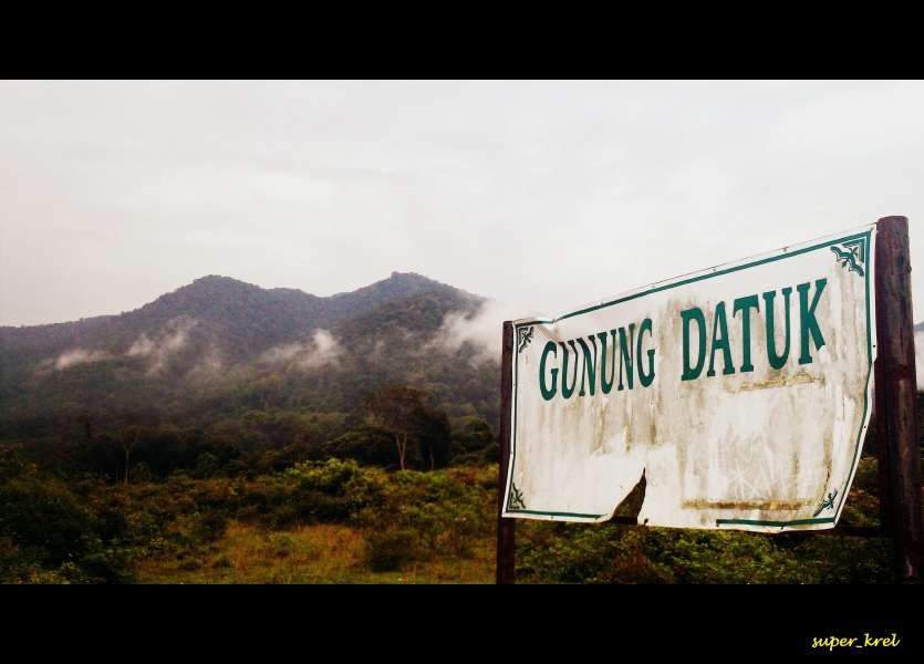
Gunung Datuk
Climbing Gunung Datuk is well worth the effort. It is quite a strenuous physical effort (at least for a middle-aged guy like me!) but at the top, once the path emerges from the thick jungle, hikers are rewarded with excellent views and a cooling breeze.
This mountain (Mount Datuk) goes by many names and spellings. On road signs it is sometimes spelt Gunung Dato’ or Datok. Some maps show it as Gunung Rembau or Gunung Datuk Rembau.
The information board at the start of the trail explains the background to the name Datuk. It seems the mountain was named after Dato’ Perpatih Nan Sebatang who in 1372 organized a gathering of leaders here to elect the future Dato’ Lembaga (clan chief).
Datuks in those days must have been a fit bunch of guys!
Gunung Datuk is 884m high (2900ft), making it slightly higher than nearby Gunung Angsi which is around 22km away. On my list of Malaysia’s Highest 300 MountainsDatuk comes in at number 220 meaning that it is a relatively minor peak but the highest one in Negeri Sembilan state on my list.
The starting point of the climb is probably less than 80m above sea level meaning that the actual height climbed is a solid 800m or so.
The distance covered is 4.6km each way as the bird flies meaning that the actual distance covered is probably considerably longer (sorry I did not measure it!).
It normally takes about 2 hours to reach the top and somewhat less coming down.
You will pass a wrecked gazebo with only the roof remaining intact. It appeared that the legs have been eaten away by termites and we saw a huge termite mound not far away.
We could hear apes whooping away and occasionally glimpsed them high in the tree tops.
Down at feet level were various insects, including a giant red Malaysian centipede (about 6 inches long and very fast moving) and what looked like monster wood-lice which rolled into a ball when disturbed.
We did not encounter any leeches but there has been a prolonged dry season this year. There are probably some after rain.
There were plenty of unusual looking mushrooms and fungus growth feasting on rotting trees.
After a while the path becomes slightly less steep and you might feel a refreshing breeze which is a welcome relief from the draining humidity. (Bring plenty of water/drinks with you. We had 1.5 liters each and it was only just enough.)
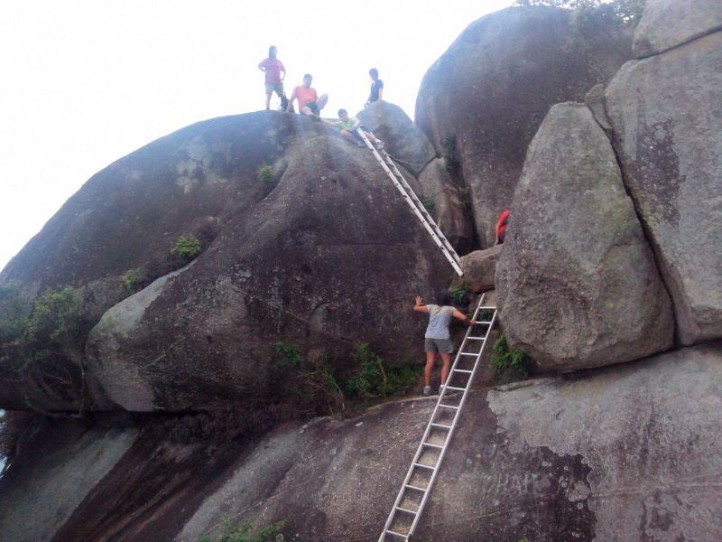
Eventually (it seems longer than 2 hours) you arrive at an open area beneath the summit which is presumably used as a campsite.
From here a number of steel ladders enable you to climb up the massive boulders which dominate the peak of the mountain. The ladders look a bit unsafe but they were not as scary as I feared.
On the summit you can rest on the flat boulders, enjoy the magnificent views and feel the cooling breeze. You are supposed to be able to see the Straits of Malacca on a clear day but it was partly hazy on our visit.
Look out for a footstep-shaped impression in one of the boulders which is said to have been made by the legendary Malaysian hero, Hang Tuah.
Coming back down is easier on the heart but hard work for the knees and leg muscles.
Contact
- CompanyGunung Datuk
- Category Attractions
- Location Kota, Negeri Sembilan
- Tag Attractions in Kota, Attractions in Negeri Sembilan, Gunung Datuk, Things to do in Malaysia
Location